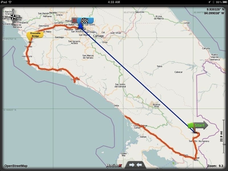
And we made it - Costa Rica December 2011

Short entry here -- it’s been a long day of flying.  We were delayed in Honolulu, but with long layovers in Los Angeles and Houston, we were fine and didn’t need re-routing.

While in Houston, we got the news that Rocky’s ashes were ready to be brought home.  Dianne volunteered to get them, and he is there waiting for us to come back home.

The first thing that struck me in the airport (besides the lateness of my suitcase at the baggage carousel) was how different it was from both Cabo and Buenos Aires.  No one was there trying to swindle you, the airport was not overwhelmed with people, and the process of picking up the rental car was easy and pleasant.  Oh, and they give directions the same way we do in Hawaii -- “go left four blocks to where the gas station used to be and stop.  Go one more block turn left and go!”  While picking up the car at Hertz, we were lectured on the new traffic laws and the insane fines for speeding.  Bottom line, unless you want to have to pay $2000 to get out of country, don’t go too fast!!!!!

We arrived on Festival de la Luz, Festival of the Light, which kicks off the Christmas type season here, and goes until Darien’s birthday - January 6th.  Although we didn’t know it, the Festival was breaking down almost directly opposite our hotel, which we drove past.  We figured we had made a wrong turn somewhere, and wound up doubling back on the Pan American highway, and going past the hotel (which I noticed this time!).  Once we figured out the under the overpass method, we were turned around and back at our hotel somewhere around 11 pm.  Amazingly, there was a casino, which was quite loud, so we put on our earphones, checked email, and headed to sleep, looking forward to meeting Darien the next day.

Estamos en camino - We're on our way to Costa Rica

Wayne and I are headed to Costa Rica tonight, sadly leaving our two kitties behind.  The trip has been marked a bit at the start by the death of our Rocky, the best raccoon kitty that ever lived.  Although we are extremely sad, we look forward to the trip, which kicks off after my last class of the semester.

Costa Rica is the only Latin American country included in the list of the world’s 22 older democracies. The country is ranked third in the world, and first among the Americas, in terms of the 2010 Environmental Performance Index. According to the New Economics Foundation, Costa Rica ranks first in the Happy Planet Index and is the "greenest" country in the world.

Costa Rica was once the southernmost province of the Captaincy General of Guatemala. A poor, isolated, and sparsely inhabited region within the Spanish Empire, it was described as "the poorest and most miserable Spanish colony in all America" by a Spanish governor in 1719. Its lack of a significant indigenous population available for forced labor prevented the establishment of large haciendas, leading to it being overlooked by Spain and left to develop on its own. Costa Rica became a "rural democracy" with no oppressed mestizo.

On September 15,, 1821, after the final Spanish defeat in the Mexican War of Independence, the authorities in Guatemala declared the independence of all of Central America. In 1823, Costa Rica became a province of the new Federal Republic of Central America, and in 1824 the capital was moved to San Jose, leading to a brief outburst of violence over rivalry with the old capital, Cartago. In 1838, long after the Federal Republic of Central America ceased to function in practice, Costa Rica formally withdrew and proclaimed itself sovereign.

Coffee was first planted in Costa Rica in the early 19th century, and was shipped to Europe in 1843, soon becoming Costa Rica's first major export and principal source of wealth well into the 20th century. The completion of a railroad system allowed for the export of bananas to the United States, and bananas came to rival coffee as the leading export.

Costa Rica has experienced two significant periods of violence. In 1917–19, General Federico Tinoco Grandos ruled as a military dictator until he was overthrown and forced into exile. This led to a considerable decline in the size, wealth, and political influence of the Costa Rican military. In 1948, Jose Figueres Ferrer led an armed uprising in the wake of a disputed presidential election between president Rafael Angel Calderon Guardia and Otilio Ulate Blanco.  The civil war that left more than 2,000 dead, after which a government junta abolished the military completely, and established a democratically elected assembly, and then relinquished its power.

The climate is tropical year round. Like Hawaii, Costa Rica's seasons are defined by how much rain falls during a particular period and not the “normal” four season. The year splits into two periods, the dry season and the rainy season.

Costa Rica’s economy, since 1999, has centered around tourism, which earns more than the combined exports of bananas, pineapples and coffee.

Ecotourism draws many tourists to visit the extensive national parks and protected areas around the country, which comprises about 25% of its land area. In May 2007, the Costa Rican government announced its intentions to become 100 percent carbon neutral before 2030 and is currently producing 90 percent of its electricity through renewable sources. Costa Rica has successfully managed to diminish deforestation from some of the worst rates in the world to almost zero by 2005.

The primary language spoken in Costa Rica is Spanish. Some native languages are still spoken in indigenous reservations. The most numerically important are the Bribri, Maléku, Cabecar and Ngabere languages.

The literacy rate in Costa Rica is 94.9%, one of the highest in Latin America. When the army was abolished in 1949, it was said that the "army would be replaced with an army of teachers." Elementary and high schools are found throughout the country in practically every community. Universal public education is guaranteed in the constitution. Primary education is obligatory, and both preschool and high school are free. There are only a few schools in Costa Rica that go beyond the 12th grade. Students who finish 11th grade receive a Costa Rican Bachillerato Diploma accredited by the Costa Rican Ministry of Education.

We will be heading to the San Vito area in Coto Brus to stay with Darien in her Peace Corps community, and are looking forward to the visit!!

Hot Springs (agua caliente)

Today started with grey skies and light rain.  Darien’s friend was bringing the sixth graders (I think) to the Wilson Gardens today, so we took her son Estaban along for a ride to the springs.  On our way there, we picked up another of Darien’s friends, Jessie, who is a third Peace Corps volunteer.

When we arrived at the springs, there were two indigenous men there already.  They started to strike up a conversation, pointing up the hill, but even Darien couldn’t understand them!  So, we ignored them.

We spent quite a while in the springs, which are warm rather than hot, and had another picnic lunch.  I am fast becoming addicted to tortillas and squeaky cheese here, made locally by Marta.  Oh, and Jessie makes killer cookies, I had to have two. 

We left sometime after eating, and dropped Jessie back off at home.  As we left, we managed to hit a big ditch filled with rocks and crunch the rental car.  Thank goodness for no deductible insurance, I highly recommend it for Costa Rica!

Post ditch, we took an alternate route back to Darien’s community, and hit a very muddy patch.  Wayne floored it, and we bounced through and out of the mud trails.  Esteban seemed to love it!  The poor car had a different opinion....

When we got home, it started to pour.  While Wayne and Darien napped, I went down to the pulperia, and got some calamaris in oil plus some sauce to make up dinner.  As we got closer to time to cook, Esteban came over.  We sipped our wine and Darien made Esteban what looked to be Tang.  It turned out his mother’s return was going to be later than expected, so we brought him in and fed him.  Post dinner, we gave him hot chocolate and got ready to watch a TV show of music videos.  Imagine my surprise that it was a review of the 80s, right down to a shirtless Michael Jackson.  No!!!!!!

We went to sleep with the sound of the rain on the tin roof.  A pleasant, quiet day.


The journey home

And so we begin the long journey back to Honolulu. We got up this morning at 4:30, and were downstairs having breakfast at 5. Our ride to the airport showed up at 6, and we checked in to LAN. After arriving in Lima, we navigated through the airport. The duty free shops are strategically located (and this applies to all the South American international terminals) right as you pass through immigration. Tricky thinking, those capitalists!

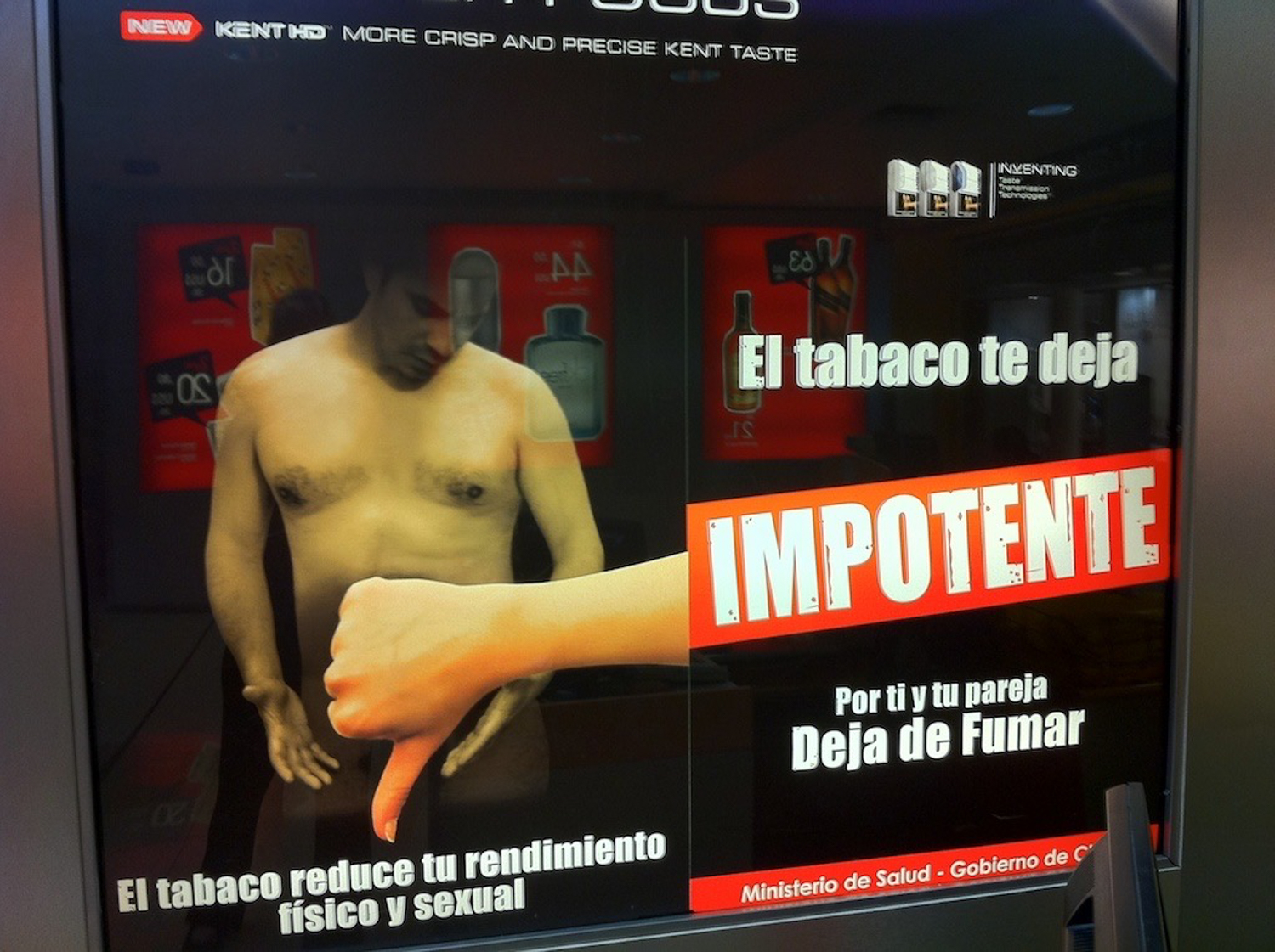
The sign below seems to cater to the Latin male ego -- instead of cigarettes causing cancer, they cause impotence! This was in the duty free shop!                                                              

MacMania 11 51.jpg

From Lima, we will go to Buenos Aires, then to Houston overnight, with two  more legs reaching Los Angeles and Honolulu. It will be a long two days of travel, with work beginning the next morning.

On the whole, I think this has been the best vacation that Wayne and I ever took together. Yes, no diving, minimal internet connectivity, but magical nonetheless. We have found a few places to which we would like to return (Uruguay, Ushuaia, Cusco and Machu Picchu), a few more we would like to explore (Lake Titicaca, Antarctica), we solidified a few friendships and created a few new ones, and we have a good deal of happy memories.

I’d do it again, in a heartbeat.

Anniversary in the (rainy) clouds

Well, we didn’t make it up to the clouds by sunrise, as it was POURING outside. We wound up having breakfast in the hotel, meeting up with the rest of the group, checking out of the hotel, and then heading back up to MP on our own.

When we got up there, the pouring rain had ceased falling, and we slid behind the group tour, saying hello to Jaques, before heading up to the very top of the compound - the guard post. There were some spectacular views, unfortunately, the majority of them were obscured by clouds. We managed one or two good pictures, and then walked back down and around. Mind you, it wasn’t a small walk, it was quite a bit of a hike. :)

When we were headed down, I was nearly run over by a Japanese group, Chinese group and German group. I wound up resorting to the old basketball technique in order to make it through - elbows out and sharpened!

We had lunch, and then went into the sanctuary lodge bar, where we met up with Leo and Jennifer Laporte, both of whom seemed exhausted! We had a nice conversation as they ate their lunch and we had a pair of pisco sours.

Who knew I would find a new favorite drink? Yummy!                                                                           

And then it was down the hill and to the market for a couple of tsotchskes (daily llama, anyone?), pick up the luggage (really two plastic bags!), surf the web for a bit, and then head back to Cusco.

Machu Picchu ( "Old Peaks") is a pre-Columbian 15th-century Inca site located 7,970 ft above sea level. It is situated on a mountain ridge above the Urubamba Valley in Peru, which is 50 miles northwest of Cusco, and through which the Urubamba River flows. Most archaeologiests believe that Machu Picchu was built as an estate for the Inca emperor Pachacuti. Often referred to as "The Lost City of the Incas", it is perhaps the most familiar icon of the Inca World.

Bingham wrote, “The sanctuary was lost for centuries because this ridge is in the most inaccessible corner of the most inaccessible section of the central Andes [trust me people, I climbed it, I agree!]. No part of the highlands of Peru is better defended by natural bulwarks - a stupendous canyon whose rock is granite, and whose precipices are frequently 1,000 feet sheer, presenting difficulties which daunt the most ambitious modern mountain climbers. Yet, here, in a remote part of the canyon, on this narrow ridge flanked by tremendous precipices, a highly civilized people, artistic, inventive, well organized, and capable of sustained endeavour, at some time in the distant past built themselves a sanctuary for the worship of the sun.” Sadly, though, the Incas couldn’t defend themselves from the smallpox the Spanish brought, so Machu Picchu survives while an inventive, intelligent race died out.

The Incas started building the estate around AD 1400 but abandoned it as an official site for the Inca rulers a century later at the time of the Spanish Conquest. Although known locally, it was unknown to the outside world before being brought to international attention in 1911 by the American historian Hiram Bingham, who has Hawaiian ties, and was a Connecticut senator. On 24 July 1911, Hiram Bingham announced the find of Machu Picchu to scholars. An American historian employed as a lecturer at Yale University, Bingham had been searching for the city of Vilcabamba, the last Inca refuge during the Spanish conquest. He had worked for years in previous trips and explorations around the zone. Pablito Alvarez, a local 11 year-old Quechuas boy, led Bingham up to Machu Picchu, where some Quechuas were living in the original structures. An interesting sidelight on manners and customs is the abundance of expressions in Quichua for all stages of drunkenness. One of their principle activities was the manufacture of beer, known as chicha.

The ruins of Machu Picchu are divided into two main sections known as the Urban and Agricultural Sectors, divided by a wall. The Agricultural Sector is further subdivided into Upper and Lower sectors, while the Urban Sector is split into East and West sectors, separated by wide plazas. Built in the classical Inca style, with polished dry-stone walls, the three primary buildings are the Intihuatana, the Temple of the Sun, and the Room of the Three Windows. These are located in what is known by archaeologists as the Sacred District of Machu Picchu.

The central buildings of Machu Picchu use the classical Inca architectural style of polished dry-stone walls of regular shape. The Incas were masters of this technique, called ashlar, in which blocks of stone are cut to fit together tightly without mortar. Many junctions in the central city are so perfect that it is said not even a blade of grass fits between the stones.

Inca walls had numerous design details that helped protect them against collapsing in an earthquake. Doors and windows are trapezoidal and tilt inward from bottom to top; corners usually are rounded; inside corners often incline slightly into the rooms; and "L"-shaped blocks often were used to tie outside corners of the structure together. These walls do not rise straight from bottom to top but are offset slightly from row to row.

The space is composed of 140 structures or features, including temples, sanctuaries, parks and residences that include houses with thatched roofs. There are more than one hundred flights of stone steps –often completely carved from a single block of granite –and numerous water fountains. These were interconnected by channels and water-drains perforated in the rock that were designed for the original irrigation system. Evidence suggests that the irrigation system was used to carry water from a holy spring to each of the houses in turn.

Machu Picchu received significant publicity after the National Geographic Society devoted their entire April 1913 issue to Machu Picchu. Since the site was never known to the Spanish during their conquest, it is highly significant as a relatively intact cultural site. Machu Picchu was declared a Peruvian Historical Sanctuary in 1981 and a UNESCO World Heritage Site in 1983, along with Cusco, and was voted one of the New Seven Wonders of the World. UNESCO describes Machu Picchu as “an absolute masterpiece of architecture and a unique testimony to the Inca civilization.”