Prior to the spring of 1946 only three nuclear explosions had taken place: On 16 July 1945, the first firing at 'Trinity site,' Alamogordo, New Mexico, using a plutonium bomb of the 'Fat Man' type; on 6 August 1945, Hiroshima, a uranium bomb of the 'Little Boy' type: and on 9 August 1945 Nagasaki, a plutonium bomb of the 'Fat Man' type.
To demonstrate the awesome power of this 'ultimate weapon,' the United States armed forces scheduled a series of three nuclear tests at Bikini Lagoon in the Marshalls with the objective of determining the effect of the atomic bomb on naval vessels in order to acquire data regarding possible changes in (a) ship design, (b) tactical formations at seas and mooring distances in port, (c) number and location of naval bases and repair yards, and (d) strategic disposition of ships. The secondary purposes were: (a) To test the effect of the atomic bomb on aircraft, both airborne and parked, and also upon a wide variety of military weapons and equipment to discover what design changes would be necessary; (b) to learn more about the effect of the atomic bomb on living beings to provide much-needed information concerning protection, early diagnosis and treatment of personnel who might be exposed to atomic explosions, either in war or peace; (c) to gain information regarding the use of an atomic bomb attack against naval task forces, compared with other types of targets; and (d) to gain further information on the scientific phenomena accompanying atomic explosions.
Originally, 'Operation Crossroads' was to have consisted of three nuclear explosions: Test 'Able' --- an air burst; Test 'Baker' -- a shallow underwater burst; and Test 'Charlie' a deep underwater burst. The first test was scheduled for 15 May 1945. But on 23 March, US President Truman postponed the date of the first test from 15 May to the 1st of June. The postponement was to permit the attendance of congressional and other observers, and originated separately from the task force, which was on schedule for the 15 May shot.
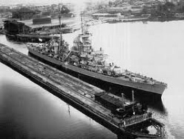
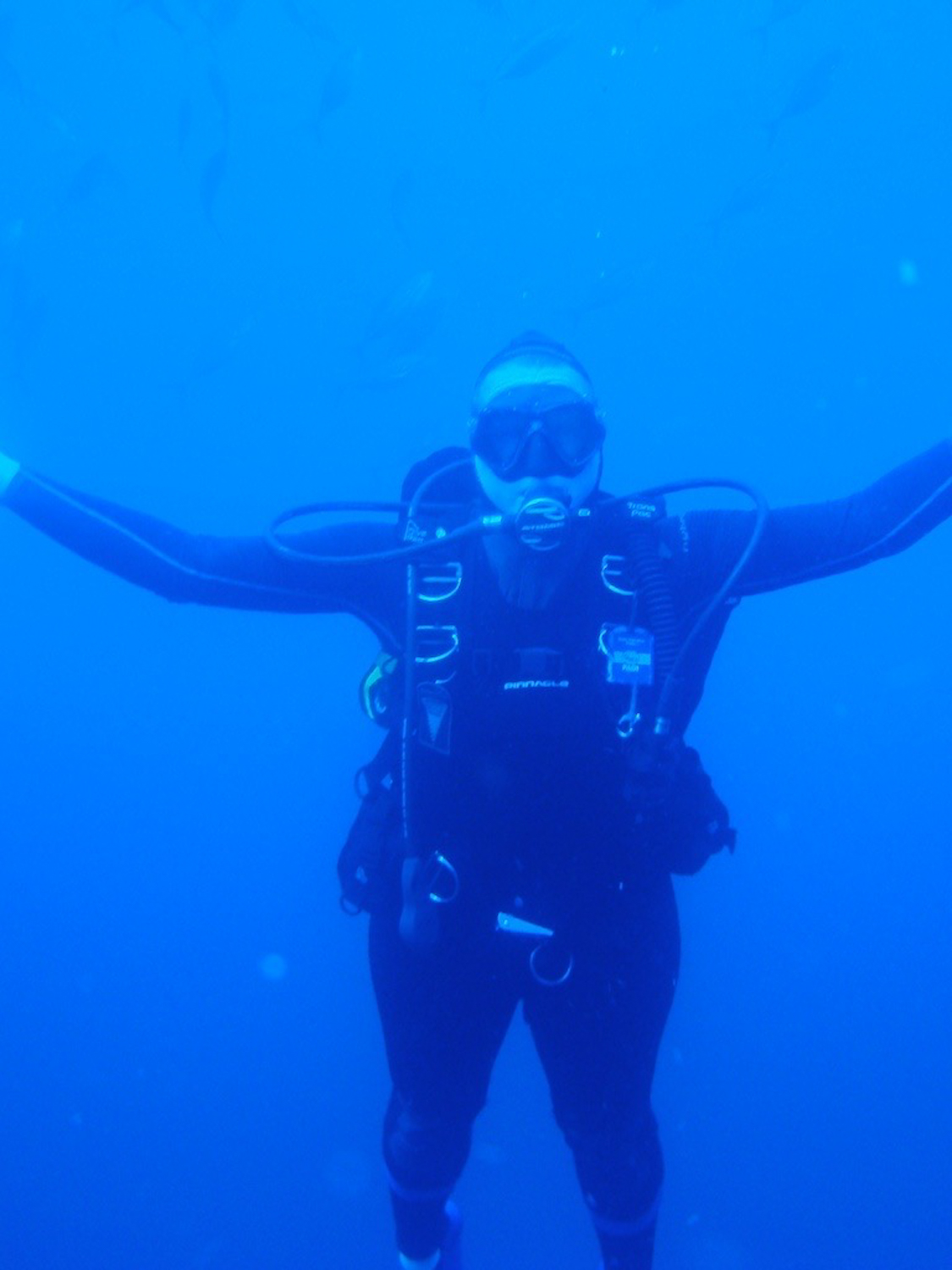
PRINZ EUGEN AT BIKINI ATOLL
But let us return to the ex-German cruiser Prinz Eugen as a unit of the 'Crossroads' target fleet. This fleet was designated Task Group 1.2 and was commanded by Rear Admiral F. G. Fahrion, flying his flag in the heavy cruiser Fall River (CA-131). Prinz Eugen belonged to Task Unit 1.2.1, which comprised five battleships and four cruisers. During June, preparations for the tests were completed, the target ships were positioned, the comprehensive instrumentation installation was completed and checked, and numerous rehearsals were held. The final rehearsal took place on 24 June, "Queen day," when a dummy bomb (a 500-pound phosphorous fragmentation bomb, not an atomic weapon) was dropped and "burst" at 0914.
1 JULY 1946: "ABLE DAY"
An Army B-29 (Aircraft serial no.44-27354, nicknamed "Dave's Dream," with call sign "Skylight One") from Kwajalein dropped Able bomb on the target fleet. With a total of 14 persons on board, the aircraft took off at 0555, with a "dry run" over the target commencing at 0820. The "live run" commenced at 0850, 50 nautical miles from the target and at a bombing altitude of 29,000 ft and a true air speed of 299 mph. The bomb fell for 48.1 sec + or - 0.3 sec before detonating. According to the technical report on the operation:
Bomb A was dropped from a B-29 plane and detonated 518 ft above the surface at 2200.34 +/- sec GCT (0900:34 local) . . . At the surface the temperature was 300C, the pressure 1012.2 millibars, and the relative humidity 68%. The wind was 11 knots from 145 deg. (true). The initial explosion quickly grew to a ball of fire which was clearly in view for 2 sec. It was then obscured by the condensation cloud. This began to thin after 4 sec and was completely gone after 15 sec. The cloud rose to 13,000 ft during the first minute; after 7 min the top was stationary at an altitude of 40,000 ft. The cloud could be identified visually for about one hour after the explosion.
One report summarized estimates of the bomb's force as follows:
The amount of energy released was "normal" for an atomic bomb of the Nagasaki type; a total of 8.0 x 10²⁰ ergs of energy was released, equivalent to the total amount of energy released in the exploding of 19.1 kilotons of TNT. The bomb missed its target, the orange-painted battleship Nevada (BB-36), which lay in the center of the array, by 710 yards. One official report stated "it detonated 710 yd from the intended plan-view position."
Immediately after the nuclear explosion, task force personnel prepared to enter the target area to assess damage. Initial boarding teams and salvage units commenced operations four hours after the explosion and boarded the target ships, starting salvage operations as soon as radiological and other safety conditions permitted. By 2030 (local) the teams had boarded and cleared 18 target ships.
Prinz Eugen's bow lay 1194 yards from the explosion at a relative bearing of 343 degrees 40 seconds, and was substantially undamaged. Only the paint had been scorched and the foremast split (see photo #3, p.65,in Warship No.9; in that photograph, one can see the scorch marks on the two port rangefinder cupolas, the so-called " Wackeltopfs"). In addition, much of the ship's rigging went down and two hammocks were blown up onto the mainmast by the blast (on the port lower spar level with the radar antenna).
Prinz Eugen was moored bow-on to the point of detonation, and transports Crittenden (APA-77) and Gilliam (APA-57), both also bows-on to the direction of the blast, lay in the direction between "ground zero" and the former German cruiser. Gilliam, only 47 yards from "ground zero" (as well as 518 ft. lower than the point of detonation), sank within one minute of the explosion. Crittenden, some 595 yards away, suffered "serious loss of military efficiency and would have been unable to operate as a transport without extensive repairs to her hull." According to the official report, Prinz Eugen had swung around on her anchors by the time of the explosion so that the starboard broadside was no longer fully exposed. The evidence of the scorch marks topside on the port side reflects the fact that the blast occurred just off the port bow. According to the damage report, the cruiser was first inspected by a Geiger radiation monitoring ship of Salvage Unit 1.2.7. on "Able Day" at about 1800 and was checked again on "Able +1 Day" at 1330.
PREPARATIONS FOR "BAKER DAY"
According to an official history, "The [accuracy] error of bombing on Able day, which had caused sinkings and damage not anticipated, forced reconsideration of the target array for Test Baker.. . The principal modifications involved substitution of alternate ships for those which had been sunk, interchange of certain ships to place those damaged in test Able in less lethal positions, and slight changes in certain other ships in range and bearing from the burst."5 Prinz Eugen lay almost twice as far from the detonation point, but at about the same aspect angle. A full scale rehearsal for Test Baker was conducted at 0905 on "William Day," 18 July 1946, when a dummy bomb was detonated on the firing barge. The assessment and salvage teams then were exercised in the roles.
25 JULY 1946 "BAKER DAY"
The bomb was lowered into the lagoon from LSM-60 to a depth of9O feet and detonated at 0835 (Mike Hour). The underwater nuclear explosion caused heavy hydrodynamic shock and heavy radiological contamination of the surrounding water.
"Bomb B detonated 90 ft beneath the surface of Bikini Lagoon at 59.7 sec after 0834 (local time) on 25 July 1946. . . The amount of energy released was normal for an atomic bomb of the Nagasaki type; a total of 8.5 x 10 20 ergs of energy was released, which is equivalent to the total amount of energy released in the exploding of 20.3 kilotons of TNT." The surface temperature was 300 C, the pressure 1011.8 millibars, and the relative humidity 73%. The wind was 7 knots from 135 deg. (true).
The underwater nuclear explosion caused a heavy hydrodynamic shock and heavy radiological contamination of the surrounding water. The official technical report continues:
"Plutonium contamination of target vessels was sufficiently great to constitute a serious danger to persons boarding the target vessels days, weeks, or even months after B-Day . . . Decontamination efforts met with varying success. Earliest efforts (involving washing away loose materials) reduced the radioactivity by a factor of 2 to 5; but subsequent efforts produced smaller improvement."
The first visual indication of the Bomb B explosion was white water on both sides of LSM-60. A dome began to rise at the rate of approximately 11,000 ft/sec. When it was about 400 ft high, bright jets of flame burst through the top. They lasted about 35 milliseconds. After 0.14 seconds, when the dome height was 570 ft, a dark colored smoke [cloud], through which flames glowed. was noticeable at the top of the dome. After 0.35 seconds the smoke formed a well-defined ball of 500 ft radius and a white stem 500 ft higher. By 0.89 sec ball and stem merged to a white-based, black-topped cone, the jagged top having a radius of approximately 970 ft and a height of 2400 ft. At 0.9 sec the condensation cloud began to form as a skirt about midway up the cone. The horizontal radius of the cloud grew with approximately acoustic velocity; it spread more slowly vertically to form a convex upper surface and a flat, sharply defined horizontal lower surface. At 0.13 sec a second ring of condensation cloud began to form below the first, and at 0.14 sec still a third ring of cloud began to expand radially and upward from the surface of the water. By 2.0 sec these clouds had merged completely. At 3.5 sec the condensation cloud, still expanding rapidly, began to thin near the base end; at 4.5 sec a vertical column of water could be clearly seen. At 7 sec the condensation cloud was still expanding radially but thinning, leaving the water column unobscured.
The column probably contained less than 500,000 tons of water. It is believed that most of this water was present as a suspension of fine drops in a hollow cylinder roughly 300 ft thick extending from 700 to 1000 ft. The density of this suspension was about six times the density of air, and by 10-12 sec the entire mass of water and air in the cylindrical shell of the column had commenced to subside at a velocity which ultimately reached more than 75 miles an hour. As the suspension of water and air fell from the column, it billowed outward over the target ships as the "base surge."
The front of the base surge moved rapidly outward, at first with a velocity in excess of 60 miles an hour. The velocity decreased linearly with increasing radius. At the same time the volume of the base surge cloud rapidly increased and the density decreased both through fall-out of water and through dilution with large quantities of air.... At its greatest extent the base surge extended to 2000 yd in an upwind direction, to about 3000 yd crosswind and to more than 4000 yd downwind. Water continued to fall out of the surge cloud for upward of 20 min.
Another official report related the following Test Baker details:
"Waves had a maximum trough-to-crest height of 94 ft at a range of 1000 ft (horizontal distance from Zeropoint) and 9 ft at 12,000 ft. The first wave traveled with a velocity of 45 knots. The waves represented less than one percent of the energy released in the explosion.
The crater produced in the Lagoon bottom was 25 ft deep; the net bottom amount of bottom material moved was over 2,000,000 cubic yards.
The explosion was detected at great distances (e.g., continental U.S.) by earth shock and by radioactivity in the air."
Prinz Eugen's bow was located 1990 yds from the point of explosion, with the ship bearing 309 degrees 8 sec from the blast point. This distance was sufficient to leave the ship relatively undamaged. By contrast, Arkansas (BB33), only 259 yds from the detonation, sank within a few seconds after "Mike Hour," while still obscured by spray and steam. She was crushed as if by a tremendous hammer blow from below." LSM60, with the bomb suspended below, "was disintegrated at "Mike Hour." Fragments were noticed to splash in several sectors of the array during the first minute after "Mike Hour"."
According to the post-explosion damage report, Prinz Eugen was not inspected until "Baker Day+8," when a ship of Salvage Unit 1.2.7 commenced washing the ship down with high pressure water. The report of the Technical Director for the tests reported that Prinz Eugen suffered "negligible or no damage related to military efficiency." The same report, however, noted "flooding and leaking" from rudder bearings and piping and fittings. By 10 August the task force's teams of specialists were carrying out detailed examinations and salvage work on the target ships in preparation for a "Test Charlie." For a variety of reasons, however, "Test Charlie" was postponed indefinitely by President Truman on 7 Sept. 1946. Preliminary planning for "Test Charlie" had called for a deep underwater burst, 1000 to 2000 ft deep, in water at least 2.5 times as deep as the bomb. Post-Baker recommendations by the test force called for "few (or no ...)" target ships, however, because "the damage which vessels would suffer could be computed with fair accuracy from the damage data obtained in Test B."14 Preparations for Test Charlie were formally terminated by Joint Task Force One two days later. Due to the radiological contamination of the surviving ships and of Bikini Lagoon itself, it was decided in late August to decommission all vessels that could not be decontaminated sufficiently to permit them to be manned again, and place them in caretaker status at Kwajalein. This movement to Kwajalein was completed in early September.
THE CRUISER'S POST-NUCLEAR FATE
On 21 December 1946, defective sea valves caused flooding in the stern section. To prevent Prinz Eugen from sinking in the southern entrance and thus blocking Kwajalein lagoon, the Atoll Commander tried to tow her downwind to Enubuj Island, in order to beach her. Successful damage control was out of the question as the only salvage vessel, Conserver (ARS-30), had departed Kwajalein to aid a ship in distress some distance away. During the night the starboard list increased to over 35 degrees and, driven by the northerly wind, Prinz Eugen ran onto Enubuj reef and capsized. In the end she was the first relatively undamaged ship of the Bikini target fleet to succumb to underwater shock damage.
The wreck lay at an angle of 156 degrees from the vertical in an average depth of 65 feet about 200 yards off Enubuj Island, and made an angle of 40 degrees with the beach. Much of her bottom, the stern, rudder and the port and the center screws were exposed, and water depth to the edge of the upper deck at the bow was 110 ft. As she lay the cruiser presented a tempting sight to the Marshall islanders on Ebeye and Enubuj who were keen to salvage some or all of the wreck for its scrap value. A Department of the Interior request to transfer the wreck to the Trust Territories of the Pacific Islands for disposal was submitted to the Secretary of the Navy in late 1973. The US Navy, as owner of the wreck, accepted responsibility for conducting a survey to determine the radiological contamination of the vessel, and the identification of special hazards. High levels of radioactivity were not expected, but even low levels were unacceptable if the material was to be introduced into the world scrap market. Further, it was not known if luminous devices containing radium were used in Prinz Eugen as was customary in warships of the period. Any evidence that radium was present in the wreck would proscribe breaking up the ship as she lay since the radium would have to be purged prior to scrapping.
The monitoring operation took place in early April 1974 and was carried out by Harbor Clearance Unit One from Pearl Harbor. During the survey it was discovered that massive hull damage does exist on the port side, in the vicinity of the after engine room, the side plating is stove in for a depth of several feet; the main deck is buckled and the side plating is torn both vertically and horizontally. The damage extends over a length of more than 50 feet and is apparently at a location which would cause flooding of two of the 13 main watertight compartments. This leads to the conclusion that salvage by hauling the wreck upright and restoring buoyancy by pumping is possible, but it would be a monumental job. There is no question but that the cost of salvage in such a remote location of the world would far outweigh the scrap value of the ship.
PART OF PRINZ EUGEN RETURNS TO GERMANY AS A MEMORIAL AFTER 33 YEARS
In 1973 the first moves were made by former crew members to seek permission for the removal of one of the screws as a memorial to the ship, and the German Navy League placed an official request with the US Navy's Chief of Operations the following year. Many high level negotiations followed until divers from Harbor Clearance Unit One were instructed to remove the port screw in 1978. After cutting the shaft and the supporting stays, the 12-ton-propeller was taken ashore by landing craft and then shipped to Long Beach. Finally, the Hapag-Lloyd container ship Rhein Express took the screw to Bremerhaven.
After the 12,000 mile journey home the propeller was cleaned and erected on a specially constructed stand beside the German Naval Memorial at Laboe and unveiled to the public on November 24, 1979.